Flat Squirrels

Quite often during our RVing adventures we come across something new to us, or something a bit odd.  The latest thing we encountered made me stop and do a little research.

Flat squirrels.

20170721_130811

Yes, you read that correctly… flat squirrels.

20170721_121230

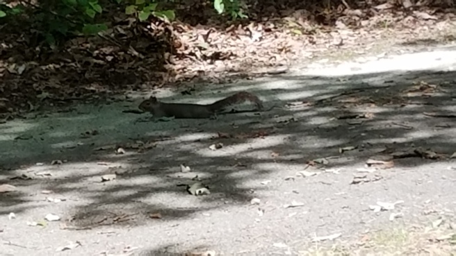
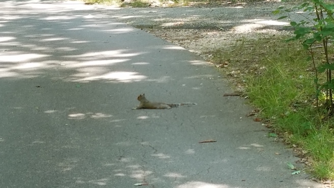
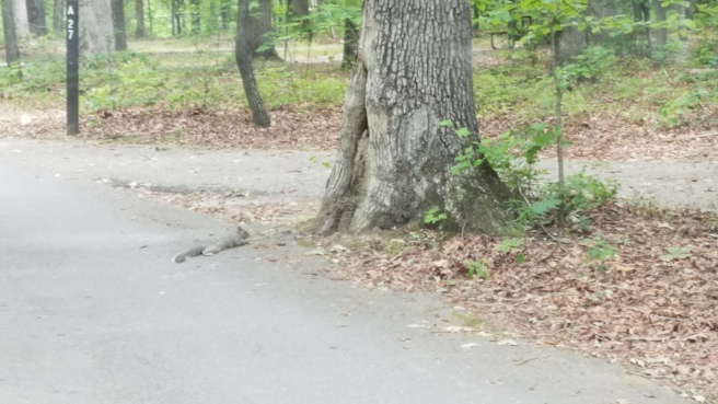
We are currently camp hosting in a national forest.  During the first couple of weeks I noticed that we kept seeing squirrels lying in the road that goes through the campground; flat on the road, spread-eagled, looking like they had been run over.  When we approached them, they would leisurely get up and amble off the road or scurry up a tree.

The first time we noticed it we were working on a task that had us going back and forth repeatedly.  As a result, we drove through the same area multiple times.  We kept coming across what appeared to be the same squirrel, lying in the same place on the road in the campground, several times during a single day.  My husband and I were concerned someone would accidently run over the squirrel, and we kept trying to figure out why it was lying there.

We theorized that maybe another squirrel had been hit there, and this one was grieving for it.  Or perhaps someone had spilled a sugary drink there, and the squirrel could smell it.  We even discussed washing down that spot in the road to get rid of any smell.

Then we noticed other squirrels doing it on other spots in the road.

20170722_130036

Finally, we did a bit of research…

Apparently, lying flat on a cool surface (like a shady campground road) helps squirrels cool down by dissipating their body heat.

Mystery solved.

I love the odd little bits of knowledge we gather in our travels!

Tugalo Park – Lake Yonah (Northeast Georgia)

For those of you that enjoy primitive camping, I recently found what I like to refer to as a “hidden gem”.

Not far from Tallulah Falls, Georgia, at the base of Georgia Power’s Tugalo Dam, is Tugalo Park.  This tiny park is right on the upper end of Lake Yonah, surrounded by the dam and the mountains. It is one of the many Georgia Power parks on the lakes.  Well-known to the locals, this little park remains hidden away from most everyone else.

The drive down to the base of Tugalo Dam is very scenic, with a view of the mountains and the forest.  It is all downhill going in, and (obviously) all uphill going out.  The gravel road is well maintained as Georgia Power workers use it on a regular basis to get to the dam.  There is quite a drop off to one side, so pay attention while driving in or out.

20170608_134453
Amazing scenery driving down to Tugalo Dam

When you reach the base of the dam, you will see the entrance to Tugalo Park.  The park has a primitive campground which consists of 10 small graveled sites, suitable for tent or truck camping.   There is a tiny building that houses restrooms with flush toilets.  There are no sinks or showers.

There is also a tiny dock, and a concrete ramp for launching small boats.  There are plenty of places to fish near the dam, and from the banks.

The lake borders both South Carolina and Georgia, so a fishing license from either state works out on the lake.  A fisherman there told us that South Carolina fishing regulations prevail on the lake; be sure to check the rules and regs!

Brasstown Falls – Westminster, SC

We took a drive today from Tallulah Falls, Georgia (where we are camp hosting) to Seneca, South Carolina.  The main purpose was to visit our bank, but we managed to have a bit of fun as well.

There are several waterfalls located off of US-76 near the Georgia-South Carolina border.  Some of them have signs along the highway, telling you where to turn off… and no further directions after that.  Locating them can be a bit of a challenge.  We decided we would pick one to stop at one on the return trip.

The first one we attempted to find was Riley Moore Falls.  Even with the help of the GPS on my smartphone, we ended up driving in a large circle without locating the trail to the falls.  At least it was a pretty drive, with some nice views!

On the hunt for Riley Moore Falls

We passed by an old mill as we got ourself back on the road.  We would have loved to have explored it a bit, but there were several “No Trespassing” signs posted.

The old mill

Further down US-76, we saw a sign for Brasstown Falls.  A quick look on the internet told us it was only about five miles off the main road, followed by a very short hike.  So off we went.

Like our previous attemp, there was no further signage.  We ended up stopping to ask someone, and having to backtrack a bit.  For the record: From US-76, you take Brasstown Road.  Follow it for approximately four miles.  The road will change from pavement to gravel.  Look for a road to the right that is not marked private; it is a forest service road.  Turn there, and follow it.  It will dead end at the trail that leads towards the falls.

The hike in was quite short, less than a quarter mile.  The trail ends a primitive camping area, part of Sumter National Forest.  However, while we could see the falls through the trees to the left of the camping area, there was no way to get to it without crossing a creek.

After falling off a log in a failed try at staying dry, we just waded down a bit, and then across.  It was not deep, and I got much wetter from falling off the log than I would have if I had just waded through it in the first place like my husband did… live and learn!

20170606_140629
The log I tried to use to walk downstream. Notice the slippery green moss on it, not my best idea!

After climbing up the opposite bank, and following a little trail through the trees, we finally got to the falls.  I think it was well worth the trouble.

20170606_135709
Little Brasstown Falls

Further down the stream, to the right of the camping area, are Brasstown Vascades, Brasstown Veil, and Brasstown Sluice.  These are reportedly lovely falls as well.  Unfortunately, I twisted my leg a bit when I fell off the log… so we decided hiking downstream would have to wait until another time.

All in all, it was a pretty successful adventure.

Spring Flowers

I was just going through the pictures I have taken in the past week and realized I hadn’t posted any of the flowers.  Things are blooming everywhere in Eastern Georgia, and I have been wildly snapping pictures as we will be moving on in less than a week.

20170326_153625
Dogwood tree at Mistletoe State Park.

The dogwoods and the azaleas are in bloom, a bit early this year.  Hopefully the flowers will hold on for the influx of golf lovers that will soon be flocking in for the Masters.

20170321_153804
Azaleas in Clarks Hill, South Carolina.

I noticed these today while roaming about the park.  Such a beautiful shade of pink!

20170326_154509
Possibly azaleas? near a campsite at Mistletoe State Park.

The bees and butterflies were certainly enjoying them!

20170326_154245
If you look closely, you can see a large butterfly on the left.

When walking the roads around the area, I have noticed all sorts of tiny flowers poking up through the leaves and grasses.  I honestly have no idea what they are, please leave me a comment if you know!

J. Strom Thurmond Dam and Lake

We have spent the past couple of months camp hosting at Mistletoe State Park, in Appling, Georgia.  Mistletoe is a lovely park; 90 shady camp sites on the banks of J. Strom Thurmond Lake (also referred to by many of the area’s residents as Clarks Hill Lake).  If you get a chance, visit the park… it’s a great place for boating, fishing, hiking, and camping!

20170219_141223_001
View of the lake from our camp site in Mistletoe State Park.

This past week, we had friends staying in the park.  We were searching for places in the area to take them that we had not already visited.  We popped into a few other nearby state parks and ended up wandering into South Carolina.  One of the places we decided to go was to see the dam that forms the lake.

20170321_152602
The dam as seen from the Visitor Center.

The lake borders both Georgia and South Carolina, and the U.S. Army Corps of Engineers operates the Thurmond Lake Office & Visitor Center in Clarks Hill, South Carolina.  The visitor center is educational and kid-friendly, with several interactive exhibits on fish and wildlife, conservation, and the history of the dam.

20170321_153014
Inside the Visitor Center.

It is also a wonderful place to snap pictures of the lake!

17310984_1296154700478433_5402069602250198593_o
View of the lake from the Visitor Center.  Photo by Tamara Klisiewicz

I never get tired of these little jaunts and side trips.  It was especially fun to have our friends Tammy and Stan along with us.  They are full-time RVers like we are, and they love to see new places.  Life on the road is always an adventure!

Washington, Georgia – A treasure trove of history

Everywhere we go, I search for historic sites to visit.  We went on one of our jaunts today – to Washington, Georgia. First stop was downtown Washington, where Jefferson Davis held his last meeting with the Confederate cabinet.

20170223_111446
Wilkes County Courthouse – Washington, Georgia

We stopped at the Chamber of Commerce and were treated to a quick history lesson of the area by an engaging gentleman. He was very enthusiastic and knowledgable, it was a pleasure to listen to him.  He sent us off with pamphlets and a walking tour map.

We walked around the area for a bit, making a stop to see inside the the Mary Willis Library. This was the first free public library in the state of Georgia. The architecture is beautiful, and the building has Tiffany stained glass windows!  The library has been expanded by adding an annex, but the original building is still intact, inside and out.

20170223_115528
Inside the Mary Willis Library

After driving around and looking at some of the wonderful old antebellum houses (beautifully restored!), we drove out to Kettle Creek Battlefield. The Battle of Kettle Creek took place in February of 1779, during the American Revolutionary War. The Loyalists were routed by Patriot militia, right here in Wilkes County, Georgia.

There are several trails and markers to show you how the battle played out.  From the top of the hill, and along the trails and the creek, you will see white crosses.  These mark the graves of men who fell in this battle.  Cadaver dogs have been brought in to locate these sites, and the historic society has marked them.  The sight of the crosses brings a sense of poignancy to your walk through this historic site.

20170223_130221
Kettle Creek Battleground – Wilkes County, Georgia

Our last stop was at Callaway Plantation, a former working plantation. It is an open air museum now, with several amazing structures on site, including a slave cabin, an antebellum house, and an old general store.  We spent quite a bit of time here, touring the buildings and talking to the director, Candice Harris.

20170223_134932
The Log Cabin – Callaway Plantation, Washington, Georgia

Candice was happy to chat with us, and unlock a barn that was full of interesting items.  She is hoping to get all of the outbuildings into shape for visitors and we are hoping to go help her do a little clean-up at some point.

20170223_140130
Inside The Brick House – Callaway Plantation, Washington

Of special interest to RVers – There is a tiny RV campground on the site.  Ten campsites total, six with hookups. Daily, weekly, and monthly rates available.

Sharing Experiences

When we first went full-time, the one thing I swore I would not do was start a blog.  Everywhere I turned on various RVer forums, there was someone promoting their blog.  The world certainly did not need another RVing blogger!

Yet, here we are.

As a fairly new RVer and camp host, the one thing I have noticed is that whenever RVers get together, they share experiences.  Whether it is stories over the campfire about where they have been, or advice on how to fix that broken awning, they share what they know.  And I felt the urge to do the same thing.

So, I surrendered to the inevitable…  Welcome to my blog!